PAP 74 - Landscape observation, a political tool
Around the monitoring programme observation of the swiss landscape
Gilles Rudaz, mars 2024
Le Collectif Paysages de l’Après-Pétrole (PAP)
Today’s landscape approach sees the landscape not as a fixed reality but as a dynamic one, in other words, one that is constantly changing. Landscapes are transformed by a variety of factors: natural factors, the way people use the land and the way they are viewed by society. The aim of contemporary landscape policies is therefore not simply to preserve a given state of the landscape, but to support its evolution. From this perspective, monitoring changes in the landscape becomes a necessary tool in the implementation of landscape policy.
À télécharger : article-74-collectif-pap_gr-.pdf (2,8 Mio), ops_suisse_uz-2219-f_labes.pdf (3,1 Mio)
Article 6.c of the Council of Europe Landscape Convention1 stresses the importance of observation in developing knowledge about landscapes. This production of knowledge presupposes the identification, characterisation and monitoring of landscape transformations.
The production of knowledge about landscapes can be seen as an instrument of landscape policy, and is even a prerequisite for it. As a result, a number of countries, regions, départements, communes and areas such as regional nature parks have launched initiatives to produce knowledge about their landscapes, including the emblematic landscape atlases. This information provides a basis for formulating the landscape quality objectives that we wish to see embodied in the evolution of a landscape. Landscape observation takes place upstream of the formulation of these quality objectives. It can then be used downstream of the formulation of these quality objectives to assess the extent to which these objectives have been achieved, or whether they are being approached, and to assess whether the strategies and instruments used enable them to be achieved. The diagram below illustrates this linkage. The feedback arrows describe the way in which the results of monitoring landscape change can interact with the definition of what we are trying to assess and how to do it (e.g. creation of a new indicator), with the objectives sought, or even the way they are formulated, and with the measures taken to achieve these objectives.
The Swiss national monitoring programme ‘Observation of the Swiss Landscape’ (OPS)
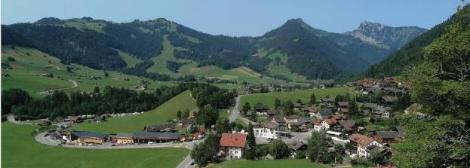
The ‘Observation of the Swiss Landscape’ national monitoring programme documents and assesses the state of the landscape and its evolution. It is based on Article 25a of the Federal Law on the Protection of Nature and Cultural Heritage (LPN): ‘The Confederation and the cantons shall inform and advise the authorities and the public on the state and importance of nature and the landscape’. This article formulates a requirement akin to a right to information. The OPS programme reports on the landscape throughout Switzerland. It therefore echoes the injunction to consider not only the so-called remarkable landscapes, but also the so-called ordinary or everyday landscapes. In line with the dual dimension of landscape, i.e. both physical and perceived, the Swiss observation programme mobilises two major groups of indicators: physical and social.
The physical dimension of the landscape First and foremost, it is important to describe the major dynamics of land cover (urban areas, infrastructure, forests, agriculture). Produced by the Swiss Federal Statistical Office on the basis of aerial photographs, the surface area statistics provide precise information on the evolution of the land in Switzerland 2. The quantitative information provides an indication of whether the surface area is remaining stable, decreasing or increasing. In the 33 years between 1985 (1979/85) and 2018 (2013/18), an area equivalent to 0.7 m² was built up every second in Switzerland, while 1.1 m² of agricultural land disappeared and 0.6 m² of woodland was added during the same period. Putting this into general perspective makes it possible to establish the pace of change and whether the evolution of one type of land is to the detriment or benefit of another.
This information on land use patterns reveals the main trends, but needs to be refined if we are to provide information on the landscape quality of these different areas. An indicator on the degree of waterproofing provides information on the quality of the built environment, while an indicator on the diversity of forms of farming provides an initial assessment of the quality of agricultural land. This indicator describes the average number of uses of agricultural land per municipality according to the agricultural structure survey. Based on the number of different crops per municipality, this diversity of farm types is increasing. It is also possible to produce ‘negative’ information. On the subject of infrastructure, for example, it is useful to take stock of its number or extent, and it is also possible to measure the proportion of open spaces where nothing has yet been installed. The specific indicator considers areas of at least 0.5 by 0.5 km where there are no buildings, roads, railways, walls, antennae or other equipment to be free of facilities. On this basis, in 2020, areas without facilities in Switzerland represented 26% of the country’s surface area. Very rare on the plateau, these areas are concentrated in the Alps 3. Two indicators specially developed by Switzerland have been adopted by the European Environment Agency for use in landscape issues. The first is fragmentation, which expresses the probability that two randomly chosen points are connected without being separated by a built-up area 4. The second is urban sprawl, calculated using a formula that takes into account the proportion of built-up areas, their spatial dispersion and the density of population and employment 5. As a result of the expansion of housing and infrastructure, sprawl and fragmentation of the landscape are continuing in Switzerland (see OPS reports).
Landscape perception
The material dimensions of landscapes are changing. At the same time, the way they are perceived by society is also changing. It is therefore important to consider perceptions of the landscape and to monitor changes over time. Based on the solid theoretical foundations identified by the Swiss Federal Institute for Forest, Snow and Landscape Research, better known by its German-language acronym WSL, the programme set out to account for the many dimensions of landscape perception. Certain criteria focus on the perceptual dimension of the landscape. This perception depends on information that may come from the landscape itself. According to information processing theory, landscapes are attractive when they encourage exploration (complexity and potential for discovery) while offering orientation possibilities (coherence and legibility) 6. Other aspects shed light on the attribution of cultural meanings to the landscape, such as uniqueness or authenticity, which the WSL describes as ‘interpreted landscape’ (Kienast et al. 2013). The method used to reveal these various dimensions of the landscape is to survey the population using a questionnaire. The questionnaire consists of various statements on which the interviewees indicate, on a gradation scale from 1 to 5, the extent to which they agree or disagree with them. An indicator results from the average of all the responses. A national survey was conducted in the summer of 2011 among a representative sample of 2,814 people, and a second survey was conducted in the summer of 2020 among 2,090 people.
The first finding to emerge from the surveys is people’s strong attachment to the landscape and their satisfaction with the landscape of their locality. The decision to work at the level of the local community echoes the notion of the everyday landscape set out in the Council of Europe’s Landscape Convention7. A comparison between the two surveys in 2011 and 2020 shows that this high level of satisfaction has remained very high. The 2020 survey, for example, gave an average score of 4.16 for the beauty of the landscape. Socio-demographic information provides further details on this estimate. For example, women, people who have lived in the same municipality for a long time and homeowners appreciate the beauty of the landscape in their municipality more than men, recent residents and tenants. The analyses also highlight the differences in perception between residents of urban, peri-urban and rural areas. Residents of the latter have a more positive assessment of their landscape. In 2020, rural dwellers gave it an average value of 4.46, while urban dwellers gave it a value of 4.05. The 2011 survey covered perceptions of the state of the landscape. This approach appeared to be too limited, and it was deemed necessary to supplement it with an examination of the perception of changes in the landscape and the appreciation of these changes. The 2020 edition therefore also looked at the perception of changes that have taken place in the municipality of residence over the past five to ten years. The indicators show that changes to the landscape have been identified, particularly in urban areas, but not to the full extent. A significant number of people interviewed were unable to say whether the landscape had changed a great deal (27%) or whether it had remained more or less unchanged (20%) in their municipality over the last five to ten years. The 2020 survey was also supplemented by a section devoted to the uses of the landscape, confirming its important role in terms of recreation (see FOEN/WSL 2022).
Putting indicators into perspective with political objectives
The OPS programme was born of a combination of a political request from the Federal Office for the Environment and the scientific expertise of the Swiss Federal Institute for Forest, Snow and Landscape Research, which developed the indicators. The results produced by this programme are subject to a political interpretation that evaluates the way in which the results of these indicators provide information on the achievement of the legal and strategic objectives for the landscape, i.e. the objectives set out in the Confederation’s laws and strategies. This political interpretation of the results of the OPS programme is the responsibility of the Federal Office for the Environment.
Alongside the legal and strategic objectives, the landscape quality objectives set out in the Swiss Landscape Concept (SLC) are central. Switzerland has had this comprehensive landscape policy instrument since 1997. This planning instrument, which is binding on the authorities, ensures that the landscape is taken into account in the various areas concerned. The SPC provides a framework for the coherent, quality-oriented development of the Swiss landscape. When it was updated in 2020, landscape quality objectives were formulated in response to a desire for operationality. In addition to sectoral objectives relating to thirteen policy areas, seven general landscape quality objectives and seven specific landscape quality objectives are set out in the Concept 9. The OPS programme is one of the measures defined to implement the SPC. It should be emphasised, however, that the OPS programme is not intended to be an instrument for monitoring the effects of policies and strategies, but rather to provide ‘a valuable basis for assessing the achievement of legal and strategic objectives’. In other words, the OPS programme acts as a compass, enabling us to measure where we are in relation to the defined objectives. It thus provides information that can be used to assess the effectiveness and relevance of the policies in place. However, it is important to stress that there is a time lag between the production of data and the effectiveness of policy measures, as the latter do not necessarily have an immediate impact. By analysing urban and agricultural textures, we are shedding light on this relationship between indicators and landscape quality objectives. The fact that the urbanised area is increasing by 0.7 m² every second shows that urbanisation is a significant trend in the evolution of our landscapes. In view of this, the landscape quality objective for the urban area summarised in the SPC is to ‘densify while aiming for quality and guaranteeing green spaces’. The surface area occupied by housing and infrastructure is almost 8% of the country. Although the expansion of these areas is continuing, the SPO’s detailed observations show that it has begun to slow down slightly. For the first time, it has fallen behind demographic growth, suggesting that the process of densification of the built environment is underway. This raises the question of what is happening in the built environment. Although the trend has slowed, soil sealing continues, increasing by 0.92% per year for the period covered by the latest survey (2009 - 2018). Because of their importance to society, and particularly in the context of climate change, PAHO is paying particular attention to green spaces in cities. According to data from satellite images, urban green spaces have disappeared at a rate of 1% per year for the period 2017 to 2020, which does not yet indicate the desirable direction of their development. In Switzerland, agriculture covers 35% of the country. The landscape quality objective for ‘landscapes used mainly by agriculture’ is summarised in the SPC as ‘conserving agricultural land and enhancing its ecological quality’. What does the OPS say? Switzerland’s farmland and grazing areas are shrinking by around 0.2% per year. On the plateaux, they are giving way to urbanisation, while in the mountains they are retreating in favour of the forest. Maintaining agricultural land therefore remains a priority. There has also been another development. Biodiversity-promoting areas’ are on the increase, and will account for 19% of usable farmland by 2020. What’s more, the increase in the number of different crops per municipality indicates an increase in the diversity of forms of farming, thereby strengthening landscape diversity. A number of indicators, such as urban sprawl, land fragmentation and soil sealing, have been steadily increasing, albeit at a slower pace in recent years. While this slowdown has taken place, the fact remains that pressures on the landscape persist.
Lessons learned
As stated above, landscapes are dynamic, meaning that they are constantly changing. Landscapes can undergo radical transformations, such as the construction of major infrastructure, but they are also subject to a multitude of specific and diffuse impacts. Indicators are needed to take account of these changes. What’s more, as the landscape evolves, so does monitoring. The system of indicators is developing to keep pace with current issues. For example, in the context of climate change, an indicator dedicated to urban green spaces has been developed using satellite images. The results of the OPS programme show that landscapes in Switzerland are still under pressure (FOEN/WSL, 2022). Indeed, a number of indicators, such as urban sprawl, fragmentation and soil sealing, are steadily increasing. However, the rate of increase has slowed in recent years. While this slowdown is encouraging, the fact remains that pressures on the landscape persist. In the press release announcing the publication of the latest OPS report, it was noted that ‘without measures to preserve and improve landscape quality, the objectives set by the Federal Council in the “Swiss Landscape” concept will not be achieved’ 10. This information on the state and evolution of the landscape is therefore useful to landscape policy in identifying the challenges with the aim of responding to them and, ultimately, enhancing the qualities of the everyday landscape and thus contributing to improving the quality of life of the population.
-
1 New name for the ‘European Landscape Convention’ since 2021.
-
2 Federal Statistical Office, 2021, Land use in Switzerland. Results of the area statistics 2018, FSO, Neuchâtel.
-
3 The plateau is the part of Switzerland between the Jura mountains to the north-west and the Alps to the south-east.
-
4 Jaeger, J. A. G., Madrinán, L. F., Soukup, T., Schwick, C., & Kienast, F. (2011). Landscape fragmentation in Europe (EEA Report, Report No.: 2). Federal Office for the Environment FOEN, European Environment Agency EEA, www.eea.europa.eu/publications/landscape-fragmentation-in-europe
-
5 Hennig, E. I., Soukup, T., Orlitova, E., Schwick, C., Kienast, F. and Jaeger, J. A.G. (2016). Urban Sprawl in Europe. Joint EEA-FOEN report. No 11/2016. Technical Report. Publications Office of the European Union, Luxembourg, www.eea.europa.eu/publications/urban-sprawl-in-europe
-
6 Kaplan R. & Kaplan S. (1989). The experience of nature. A psychological perspective, University Press, Cambridge.
-
7 The Swiss Federal Statistical Office conducts a similar survey of people’s satisfaction with the landscape. It uses the term ‘landscape around the home’.
-
9 The text of the Conception is available at www.bafu.admin.ch/conceptionpaysage
-
10 www.bafu.admin.ch/bafu/fr/home/themes/paysage/communiques.msg-id-93612.html