PAP38 - The Earth is not flat
How to use terroirs to reclaim the biodiversity and landscapes of rural areas
March 2020
Le Collectif Paysages de l’Après-Pétrole (PAP)
Anxious to ensure the energy transition and, more generally, the transition of our societies towards sustainable development, 40 planning professionals have come together in an association to promote the central role that landscape approaches can play in land-use planning policies.
In this article François Tacquard, agricultural engineer, director of D.A.T. Conseils (territorial planning, development, development, tourism), invites us to better understand the complexity of ecosystems in the relationship between territory and landscape.
To download : article-38-collectif-pap-ft-1.pdf (2.7 MiB)
As an agronomist, I am always amazed by the simplistic discourse on rural areas: villages in France are surrounded by a flat, intensive agricultural area, punctuated here and there by a few forests and wetlands. Consequently, the establishment of a « green and blue grid » that could link these same forests and wetlands as reservoirs of biodiversity would make it possible to safeguard what remains of rich environments. These provisions would be accompanied by some prescriptions for less intensive agriculture, whose phytosanitary treatment practices should remain more than 150 metres away from houses.
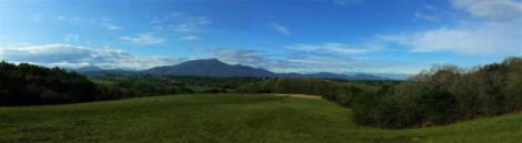
This representation is far removed from the reality of the territory since six or seven terroirs organise different ecosystems and agronomic potential around each village in Europe according to soil, humidity, slope and exposure.
This diversity is neither named nor used today in public policies.
A wide variety of ecosystems
Even before man settled there, the areas of temperate Europe were composed of very varied ecosystems, coexisting over a few hundred metres: wetlands along river banks and in the lowlands, dominated by alders, willows and ash trees; beech woods - oak groves on the terraces or fertile plateaus; hornbeams - oak groves on the southern slopes, with conifers settling rather on the northern slopes; moors or dry grasslands on the thin soils of the summits or plateaus.
After many mistakes, the farming communities gradually learned to use these various areas rationally and created complex agrarian systems around the villages, making the most of each terroir and creating typical landscapes in each sub-region.
For example, in temperate Europe, until the beginning of the 20th century, the bottoms of humid valleys were used as hay meadows; terraces and plateaus with deep soils became cereal lands; the southern slopes were used for vineyards or orchards; the often meagre hilltops were used as collective pastures; forests remained confined to the least fertile areas. Belts of gardens and orchards surrounded almost every village on our continent.
The cultivation of natural areas has not always been synonymous with biological impoverishment. New ecosystems were created, sometimes richer in biodiversity than the original environments, for example in the case of terrace cultivation or permanent pastures. In these traditional systems, farmers were generally multi-purpose, combining agriculture and livestock farming, which allowed manure to be transferred from one area to another. Local resources were optimized.
In temperate Europe, the excessive deforestation that persisted until the 18th century was corrected in the 19th century by reforestation policies and the creation of forestry services. The enrichment of farmers observed at the end of the 19th century thanks to improved techniques and the possibility of selling local agricultural surpluses in towns made it possible to create a very high quality rural landscape: composed of five to ten terroirs depending on the region, it is well managed and quite rich in biodiversity. In the mountains, the layering of vegetation creates additional opportunities.
It is from the 1950s onwards, with the development of intensive and specialized agriculture, that these terroirs are gradually eroded and the ecosystems impoverished: for example, wetlands are drained and stony and poor land is crushed to make land for cereals. These practices have a financial cost: it is more expensive in inputs (fertilizers, pesticides) to produce on bad land than on good land. The ecological cost is also heavy: there is a lot of pollution (more inputs are needed, partly washed out by the rain) and the development of this land causes major disorders (soil erosion…). The « land becomes flat » and the landscapes are homogeneous.
In the mountains, slopes that are too steep and unsuitable for mechanization are abandoned and covered with wasteland to the detriment of certain original ecosystems and picturesque landscapes. They are sometimes covered with mono-specific resinous plantations, very poor in biodiversity, which today are partly dying because they are unsuited to the soil and to global warming.
Failure to respect the terroirs leads to ecological impoverishment and weakens rural landscapes. Yet these terroirs still exist, even if they are masked by intensive practices: poor soils remain poor, dry soils on southern slopes remain dry and wet soils remain wet as soon as they are no longer drained. Slope and exposure are constants. The geology and morphology that have made up more than 90% of the soils and terroirs remain very stable over the centuries.
Using each terroir in a differentiated way
If we want to recreate strong biodiversity and shimmering rural landscapes in our European countryside, we must once again use each terroir in a differentiated way in each village.
1. It makes sense to continue to intensively cultivate the best land (the ager 1 of the ancients), in the most suitable speculation for this territory, generally in cereals. But farming practices must be reasoned, by limiting inputs, fertilizers and pesticides, and above all by redeveloping a humus rate as recommended by France during the Paris climate agreements, with the « 4 per 1000 » initiative 2. If more carbon were stored in the soil by taking action to increase soil humus by 0.4% per year, this would help offset the continuous rise in carbon emissions of modern civilization. Better still, it would improve agricultural production, as the presence of carbon in soils makes them more fertile. The FAO 3 rightly estimates that half of the world’s fields are now degraded, i.e. their yields are declining, leading to an overall drop in agricultural production of around 10%.
2. In the same small territories, it is necessary to de-intensify the most humid or poorest agricultural terroirs (the saltus 4 of the old ones) with diversified agricultural systems. This implies reintroducing mixed cropping and livestock farming in all villages, preferably in organic farming to make the most of these less productive areas. Wetlands must return to permanent grassland; poor or dry soils must return to sylvo-pastoralism, or even to the renovation of arboriculture terraces. These terroirs are capable of producing high-quality, organic food that is sold at a higher price, which can contribute to their profitability.
3. The forest (the silva 5 of the ancients) must also regain its diversity through more natural management methods, such as forest gardening. In mountain areas, where forest occupies a major part of the territory, strict protection is not always desirable: a mountain pasture is ten times richer in species than a spruce plantation, and it is capable of capturing as much carbon as a forest. The excessive legal protections voted recently do not take into account the real territory and are a contradiction in terms for biodiversity.
The richest (and therefore fairly intensive) lands make up 10 to 60% of the terroirs, depending on the agricultural region: 60% in cereal-growing regions such as Beauce, 10% in mountain regions with extensive agriculture. It is therefore possible to develop a high level of biodiversity in mountain areas. But even in lowland areas, almost 40% of the areas of the municipalities should participate in the restoration of high quality ecosystems.
Comprehensive biodiversity and landscape (eco-landscape) plans should be defined in each municipality (or group of municipalities), which would be binding on agriculture with financial compensation for services rendered to the common good.
The analysis of the history of land use in each village is easy thanks to old maps, accurate since the 18th century. These documents give relevant indications on the terroirs and therefore on a strategy for good management of the rural space.
Experiments have already been carried out in this direction in areas that have drawn up and implemented a landscape plan, and then managed to mobilise public funding for environmental services in agriculture, agri-environmental measures: premiums are given to farmers if they cultivate such terroirs in a certain way. In general, the areas concerned are small (a wetland, a particular moorland, etc.). There is no global and coherent management of a small area, landscapes and biodiversity do not improve significantly. In this context, the qualitative sectors capable of exploiting the terroirs richest in biodiversity cannot develop.
Measures to finance these environmental services of agriculture are extremely minor in the Common Agricultural Policy (CAP). In France, they account for only a few percent of the nine billion paid annually by Europe to farmers. Intensive sectors are, for their part, abundantly financed.
So the problem is not a lack of money. A more coherent common agricultural policy would consist in directing at least half of European funding towards good land management, while encouraging quality sectors in the most sensitive areas. Our beautiful Europe would find richer environments and farming landscapes there!
The accumulation of partial protection
The accumulation of partial protection in a rural area leads to inconsistent management.
Most rural areas are subject to a wide variety of protection measures: town planning documents, Natura 2000 areas, green and blue belts, protection of rivers, protection of sites and environments, protection of forests, etc. The superimposition of these protections frequently gives rise to inconsistent actions. The law of 2014, for example, strictly protects forests in France, including micro afforestation of spruce trees that destroy the ecosystem of wetlands or pastures that are very rich in biodiversity, which are otherwise protected. Another example: the green and blue grid connects biodiversity reservoirs by « corridors » drawn on a map and which often do not correspond to any geographical and ecological reality, thus fabricating dummy constraints that cannot be respected on the ground. A third example is the creation of protected wetlands immediately adjacent to large areas of intensive maize-growing, where irrigation and pesticides have a significant impact on the environment: the rural ecological space and the water table are greatly weakened as a result.
Only a comprehensive approach to coherent land management can make it possible to preserve or regain biodiversity and landscapes with and through qualitatively productive agriculture. Entering through eco-landscapes makes it possible to draw up a territorial project that integrates the good management of landscapes and natural environments.
A tool for good land management, the ecological and agrarian landscape plan
Several valleys of the Vosges massif have developed their landscape plan over the last thirty years to control the excessive growth of woodland and slow down anarchic urbanisation. Built at the intermunicipal level, these landscape plans first analysed the historical evolution of land use. Then they defined strategies for the good management of landscapes and natural environments. The recognition of terroirs is an integral part of this approach, with for example :
-
The restoration of permanent valley bottom meadows to mowing land - a late mowing to preserve biodiversity, following the removal of the anarchic spruce microforestation that clutters them up.
-
The clearing of the village’s edge pastures, which are very rich in biodiversity when managed extensively, with the removal of mono-specific forests and young coppice.
-
The modification of forest management to transform spruce plantations, poor in biodiversity, into garden and mixed forests, richer and more stable in the face of climate change.
-
The protection of high pastures, called stubble.
-
The identification and protection of small rural and built heritage.
Today, the virtuous approach of landscape plans increasingly integrates ecological needs through eco-sylvo-pastoral projects. Supported by the two regional nature parks in the Vosges massif, it should be recognised by all administrations.
However, this approach is contradicted by recent laws which require space planning projects to be dealt with on an ad hoc basis and by different administrations. For example, the slightest clearing of land in an extremely wooded area, even though it is provided for in the landscape plan, becomes a real obstacle course: the laws are jostling, requiring procedures that are piling up on the ground, with enormous administrative constraints that discourage them: water law, biodiversity law, forest protection law, Natura 2000, etc.
Such measures lead to a fragmented vision of space, which is contrary to good sustainable management. The technicians in charge of implementing recent laws often do so aspect by aspect and without taking an interest in the overall field project. The elected representatives of the Vosges mountains and the technicians of the parks and communities of communes recently organised a meeting on this subject to highlight the crisis of confidence induced by a rigid application of protection laws.
Conversely, the coherent eco-landscape project, carried by a whole rural community and discussed with the administrations concerned, must become the basis for the analysis of local projects.
1 Ager is a Latin word meaning cultivated field in the European rural landscape.
2 The international initiative « 4 for 1000 », launched by France on 1 December 2015 during Cop 21, consists of bringing together all voluntary public and private actors (states, local authorities, companies, professional organisations, NGOs, research institutions, etc.) within the framework of the Lima-Paris action plan. The initiative aims to show that agriculture, and in particular agricultural soils, can play a crucial role in food security and climate change. www.4p1000.org/fr.
3 Food and Agriculture Organization of the United Nations. www.fao.org/home/fr.
4 For the Romans and Gallo-Romans, saltus was uncultivated or wild land (more or less wooded areas), possibly used for livestock farming or, more specifically, grazing.
5 Silva is a Latin word meaning forest.