PAP 57: the narrative map, a tool for thinking together about the future of the Seine Valley
Joséphine Billey, Alexia Fesquet, Agnès Jacquin, Benoît Labbouz, Alexis Pernet, April 2022
Le Collectif Paysages de l’Après-Pétrole (PAP)
Anxious to ensure the energy transition and, more generally, the transition of our societies towards sustainable development, 60 planning professionals have joined together in an association to promote the central role that landscape approaches can play in regional planning policies. In this article, the landscape designers 1 present the narrative map as an educational tool for reflection and innovation
To download : article-57-collectif-pap_vds.pdf (11 MiB), cn_note_methodologique_vf_pages.pdf (2.5 MiB)
Rising sea levels, intense storms and floods, increasingly long and frequent droughts: the hazards associated with climate change are already being felt. They invite territories to anticipate their adaptation and to imagine the possible forms of their evolution. At the request of the State and the Normandy and Ile-de-France Regions, a landscape network has been run since 2015 by the École nationale supérieure de paysage (ENSP), in partnership with the Le Havre-Estuaire de la Seine Urban Planning Agency (AURH). This network has engaged in active landscape awareness work as part of the Seine Valley development project.
This approach has been awarded at the Palmarès du paysage 2022 « for the innovative aspect of its participative design tools and for reaffirming the fundamental need for collaboration between foresight and action for a practice of landscape through research ». In 2020, planning professionals were asked to define a scenario for cooperation between the two regions to adapt to climate change. The graphic translation of this scenario was proposed in the form of a narrative map Imaginons la vallée de la Seine de demain (Let’s imagine the Seine valley of tomorrow) which shows in detail the possible future of the landscapes between Paris and Cherbourg. This article reviews the ambitions, methodology and choices made by the members of the landscape network to produce this map.
The landscape network of the Seine valley
The Seine valley is a space of national, interregional and local interest, whose global dimension is affirmed in the « Seine Axis » project since 2015. Linking Paris to Le Havre to make it the capital’s seaport, the valley is becoming a logistical corridor whose spaces must be thought out in their coherence. Appointed interministerial delegate for the development of the Seine Valley, Prefect François Philizot is building a strategic development plan for the Seine Valley up to 2030 with the Normandy and Ile-de-France regions.
In terms of territory, the project includes the departments of Paris, Hauts-de-Seine, Seine-Saint-Denis, Yvelines, Val d’Oise, Seine-Maritime, Calvados, Eure and La Manche. In terms of project themes, it addresses the development of the Seine Valley in an integrated manner, combining approaches to spatial planning, flow management and economic, tourism and cultural development.
To implement this strategic plan, the State and the two Regions have drawn up an interregional State-Regions plan contract (CPIER) for the Seine Valley which they signed in 2015. The process underway provides for the exploration of forms of project based on and reinforcing the elements of landscape quality of the Seine Valley in their monumental as well as everyday dimensions. Entitled Knowledge of landscapes and their evolution, action sheet 1.3 of the CPIER was then constructed in order to identify and characterise the landscapes of the Seine Valley in order to guide their development. Thus, since 2015, the École nationale supérieure de paysage has been responsible for building and leading a cluster of actors grouped around landscape skills with the support of the Le Havre-Estuaire de la Seine Urban Planning Agency.
A landscape network formalised as such is then constituted. It gathers institutional actors, elected officials, professionals and students from Normandy and Ile-de-France in order to promote the joint construction of projects enhancing the living environment and the environment of the Seine valley and bay areas. In addition to the major design projects revolving around the Paris metropolis, such as Dessine-moi le Grand Paris (Île-de-France Regional Council) or Réinventer la Seine (Cities of Paris, Rouen and Le Havre), the focus is on developing and supporting landscape skills within the perimeter defined by the Seine Valley plan contract. The ambition is to highlight the values of this living area, whose future should not be considered solely from a heritage or technocratic point of view, but by defining which contemporary uses to develop based on local natural and cultural dynamics. Beyond the institutional and professional players, the aim is to strengthen the sharing of experiences, transdisciplinarity and innovation by involving all the players concerned in the setting up of projects. These projects will aim to reveal and reinforce the value of the landscapes between the Parisian metropolis and the Normandy coast.
Five years of exploration of the Seine Valley
Between 2015 and 2020, the Ecole de Paysage and the Agence d’Urbanisme organised several events each year, which were open to a wide range of actors from Normandy and Ile-de-France concerned by regional planning. On the basis of participative approaches often reinvented, they have animated this landscape network by experimenting tools aiming to raise awareness of the realities of landscapes from the diversity of expert approaches through which good decisions are made. Through regular exchanges, the landscape network tries to go beyond the sectorial work habits by proposing to elected representatives, technicians, professionals and students to cross their approaches in new formulas favouring reflection. Pedagogical workshops with ENSP students, professional workshop-tours, « network meetings », inter-school travelling workshops or even landscape caravan, all these formats set up by ENSP and AURH aimed at creating a collective intelligence at the service of territories.
The annual pedagogical workshop has landscape design students at the end of their training work for a few months on a current landscape theme in the Seine valley: industrialisation, tourism, archaeology, cycle routes…. Through their design skills, the students open up horizons that allow local stakeholders to envisage landscape projects that enhance the potential of the sites studied in the perspective of an integrated development of the valley. The first educational workshop held in 2015 highlighted the monumental qualities of the Seine, inducing an unlimited responsibility that each of the actors of the territory must demonstrate in their projects, at all scales. It resulted in a publication, La Seine, un monument libre, (ENSP Versailles, 2017) inaugurating a series that regularly relays the network’s approaches. Subsequent workshops have focused on more local themes, chosen on the basis of discussions with local actors.
The workshop-trip is organised every spring for professionals and elected officials from Normandy and Ile-de-France. The first day offers field visits and meetings with local stakeholders to enhance their knowledge of the site and its issues. On the second day, the participants are brought together in workshops for a collective production. They must project themselves and identify future perspectives for the landscape they have encountered.
The student and inter-school workshop is a ten-day field trip. Open to master’s students from schools in the two regions between Paris and Cherbourg, the workshop studies a major theme for the future of the valley: development of river tourism, creation of cycle routes, future of agricultural landscapes, etc. In order to question the developments of today and tomorrow, a reflection is carried out with future professionals motivated around the major projects of the territory.
The « re-entry of the landscape network » is an autumn day organised every year. The ENSP and the AURH share the results of the work carried out during the year, present the last published documents and announce the calendar of the next events. This day, which is open to all, is an opportunity to discover the approach. The members of the network meet to establish new partnerships.
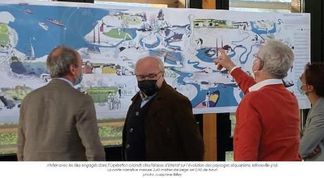
The landscape caravan has been travelling between Paris and Cherbourg since 2021. It meets with planning professionals, elected officials and the general public, and offers a time for exchange and active dissemination of the productions carried out since 2015. Each stopover is designed and run in partnership with cultural establishments, higher education institutions, associations and local authorities, selected on application. These stopovers use the conference L’Odyssée séquanienne and the book Plus grand que la Seine, acteurs en réseau, paysages en projets (Editions Parenthèses, 2021) to present the landscape approach and raise awareness of the importance of adopting planning practices adapted to the hazards of climate change. The narrative map Imaginons la vallée de la Seine de demain was created for this purpose.
The need for a synthesis tool
The many prospective workshops organised by the ENSP and the AURH have engaged the network’s professionals in collectively considering the possible futures of the Seine territories by placing the landscape at the heart of the reflection. At the end of these workshops, a scenario of cooperation between the two regions emerged, highlighting the complementarity of the territories and how different planning practices could be envisaged tomorrow in response to the hazards of climate change. In order to overcome certain limitations of conventional media - maps, diagrams, graphs, etc. - in conveying the changes at work and to best disseminate the prospective scenario envisaged, a narrative map was devised to combine the realism of a geographical map with the multiplicity of points of view and the flexibility offered by fictional accounts. This map, the result of a year’s work, is presented on the cover of the collective work Plus grand que la Seine. Actors in network, landscapes in projects.
Foresight workshops to build a scenario for interregional cooperation
Taking into account the fundamentally uncertain nature of the future, foresight consists of constructing representations of the future in order to discuss them with the actors concerned. At the end of 2019, the foresight approach orchestrated by the ENSP and the AURH aimed to anticipate and collectively exchange on the subject of the development of the Seine Valley and the Normandy coastline, since the upheavals in the climate will lead to the necessary renewal of the economic, industrial and tourist activities that are the basis of the national influence of this territory. The landscape approach used for this exercise made it possible to cross-reference the participants’ expertise and bring them together, giving each of them the opportunity to anticipate the hazards, but also to rethink the ways in which the territories of the Seine are developed, practised and inhabited. The elaboration of the map was nourished by the results of the two workshop trips mentioned above. These workshops invited a variety of professionals and students involved in regional planning (Council of Architecture, Urbanism and Environment, regional nature parks, large companies, local authority agents, conservatories of natural areas, urban planning agencies, artists, architects, independent landscape designers, universities, etc.). The first workshop-trip Imagining the Seine Valley of tomorrow brought together some forty participants in Le Havre. It identified eight themes - tourism, industry, habitat, ecological continuity, agriculture and food, energy, transport, and the movement of land and inert materials - for which solidarity and interdependence between Normandy and the Île-de-France region are major issues. By highlighting the links and interdependencies between the two regions, the prospective scenario proposes to replace territorial competition with reciprocity and complementarity. Subsequently, the consultation of experts, selected for their knowledge of one or more of the eight themes, provided input for the synthesis and in-depth work. The second trip-workshop, Let’s design the Seine Valley of tomorrow, specified the cooperation hypothesis retained for each theme. It led to the identification of adaptation objectives and planning methods and initiated the graphic translation of the scenario.
Construction of the narrative map
IGN maps, topographic maps and development plans are all tools used daily by landscape architects to find their bearings and convey their ideas. Classical cartographies allow « the representation of space according to rigorous mathematical measures " 2 in a simple and comprehensible manner. They are not intended to reflect the dynamics of territorial transformation. Since environmental crises are upsetting the collective imagination because of their exceptional nature, their scope and their speed, it was necessary to try to overcome the limits of conventional media in order to account for foreseeable changes. In order to best disseminate the prospective scenario developed by the group, the ENSP and the AURH decided to develop a graphic representation whose realism is that of a geographical map, but which also shows the diversity of points of view and possibilities of anticipation. The climate challenges encouraged the landscape network to invent this new form of map to integrate narrative elements from the scenario and facilitate its discussion with the stakeholders.
Built thanks to the work carried out throughout 2019-2020, the narrative map embodies the scenario of cooperation between the two Regions to adapt to climate change on the basis of twenty landscape focuses. Each of these focuses combines different themes (agriculture and housing, energy and ecological continuity, industry and tourism, etc.) encouraging a diversity of land uses and the multifunctionality of places. In order to make the switch from writing to graphic translation, numerous trips to the field were made. This time spent spotting and collecting information fed the analysis of the existing situation (vegetation, urban structures, geographical base, colours, atmosphere, etc.) and inspired the definition of the angles of view for each focus. By freeing ourselves from an overhanging view, by multiplying the perspectives, depths and scales represented, we decided to go beyond the normative codes of conventional cartography. Subsoils, root systems, material links such as transport networks and immaterial links such as networks of actors have their place in the narrative map. It mixes visible and invisible, permanence and movement of the territory. The graphic language has been chosen to facilitate the appropriation of the tool by a large public of neophytes as well as landscape and planning experts. The coloured flat tints build the geographical context of each scene by representing the main features of the Seine valley: the hillsides, the chalk pinnacles, the meanders, the islands, etc. The flat characters represent the actors who live in or move around the place. In counterpoint, the wireframe drawings build the narrative and highlight the diversity of uses, practices and trades that make this future possible. The drawing highlights the way in which development and management practices can prepare for the adaptation or degradation of environments according to climatic conditions. The large horizontal format of the document offers a dynamic reading of the scenario and encourages immersion in the Sequanian landscapes. As the viewer moves through the image, he or she is invited to adopt the perspective of a boatman, a salmon, a landscape gardener, an earthworm, a businesswoman or a seagull.
Immersion in a landscape focus
Each focus focuses on a central question, inviting the audience to debate. For example, one focus asks the following question: how can the infrastructure of the Seine be made more permeable for all its users? All along the Seine valley, the major infrastructures - ports, roads, business parks, dams, etc. - create a set of monofunctional barriers that segment the territories and environments. In the image extract, the lock shown is no longer a place crossed only by boats. It becomes a link between the two banks for cyclists and pedestrians, but also a crossing point for fish.
The discussion of the scenario in the heart of the territories
Far from providing a single answer or definitive solutions, the graphic translation of the scenario shows a multitude of options that aim to respond to the challenges of climate change based on the complementarity of the territories. The narrative map and its focus areas are thus supports for debating the relationships between the themes, the frictions they raise and the balances that will have to be found for the development of the Seine Valley today and tomorrow.
The interest of this foresight exercise also lies in the dissemination, appropriation and interpretation of the illustrated scenario that it opens up for a wide range of stakeholders. Playing the role of support and facilitator of discussions on the future of the territory, the need to make choices leads to fruitful questioning. The ENSP and AURH facilitation team will be travelling on the landscape caravan from April 2021 to offer this tool to the people of Normandy and Ile-de-France. The conduct of a dozen workshops with different audiences - elected officials, students, economic actors and technicians - has demonstrated its ability to facilitate exchanges around the theme of climate change and the practices that would allow us to adapt to it. Its abundant and composite character has proved to be an invitation to meet and share between territories, economic sectors and professionals. By proposing that everyone project themselves into 2050, this scenario encouraged participants to take a step aside to overcome tensions, differences and territorial contingencies and succeed in collectively debating the development of the Seine Valley and the Normandy coastline as a whole. In the Seine territories, the narrative map thus contributes to demonstrating that the landscape is not a simple background but offers a real potential to draw a future trajectory.
-
1 Joséphine Billey, dplg landscape designer, project manager for the « Seine Valley » programme, École nationale supérieure de paysage. Alexia Fesquet, urban landscape designer, sustainable development assistant, Le Havre-Estuaire de la Seine Urban Planning Agency. Agnès Jacquin, landscape designer, project manager for the « Seine Valley » programme, École nationale supérieure de paysage. Alexis Pernet, dplg landscape designer, teacher and lecturer, École nationale supérieure de paysage.
-
2 Nicolas Houzelot, director of the National Archives Quand les artistes dessinaient les cartes, Le Passage Paris-New-York Éditions et Archives nationales, 2019.